
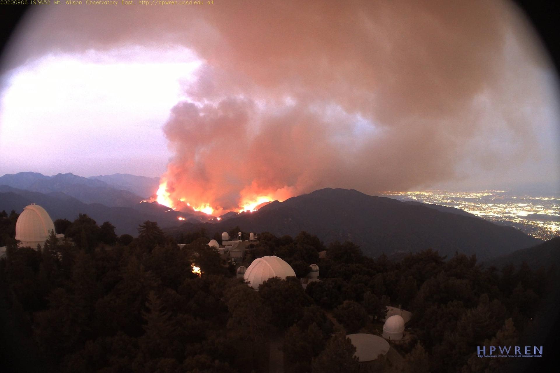
The Bobcat Fire started in the Angeles National Forest in the afternoon on September 6th near the Cogswell Dam and West Fork Day Use area.
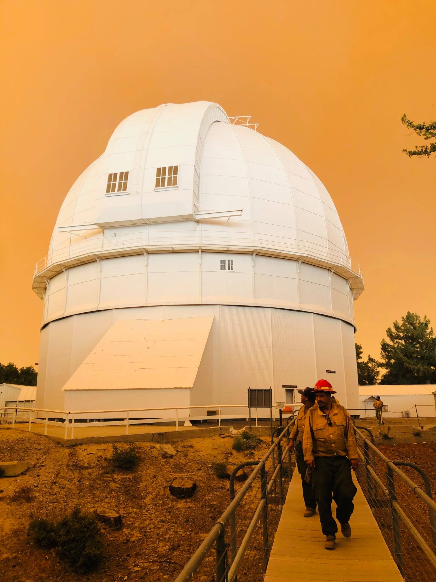
All non-essential staff were evacuated from Mount Wilson on the morning of September 7th, 2020. As a result, the CHARA Array is currently closed, and we have suspended observations. We plan to reopen when staff can return safely to the mountain and when the smoke and ash clear.
Current conditions can be monitored from the Mount Wilson HPWREN Cameras.
Update - 2020 Sep 13
By Chris Farrington
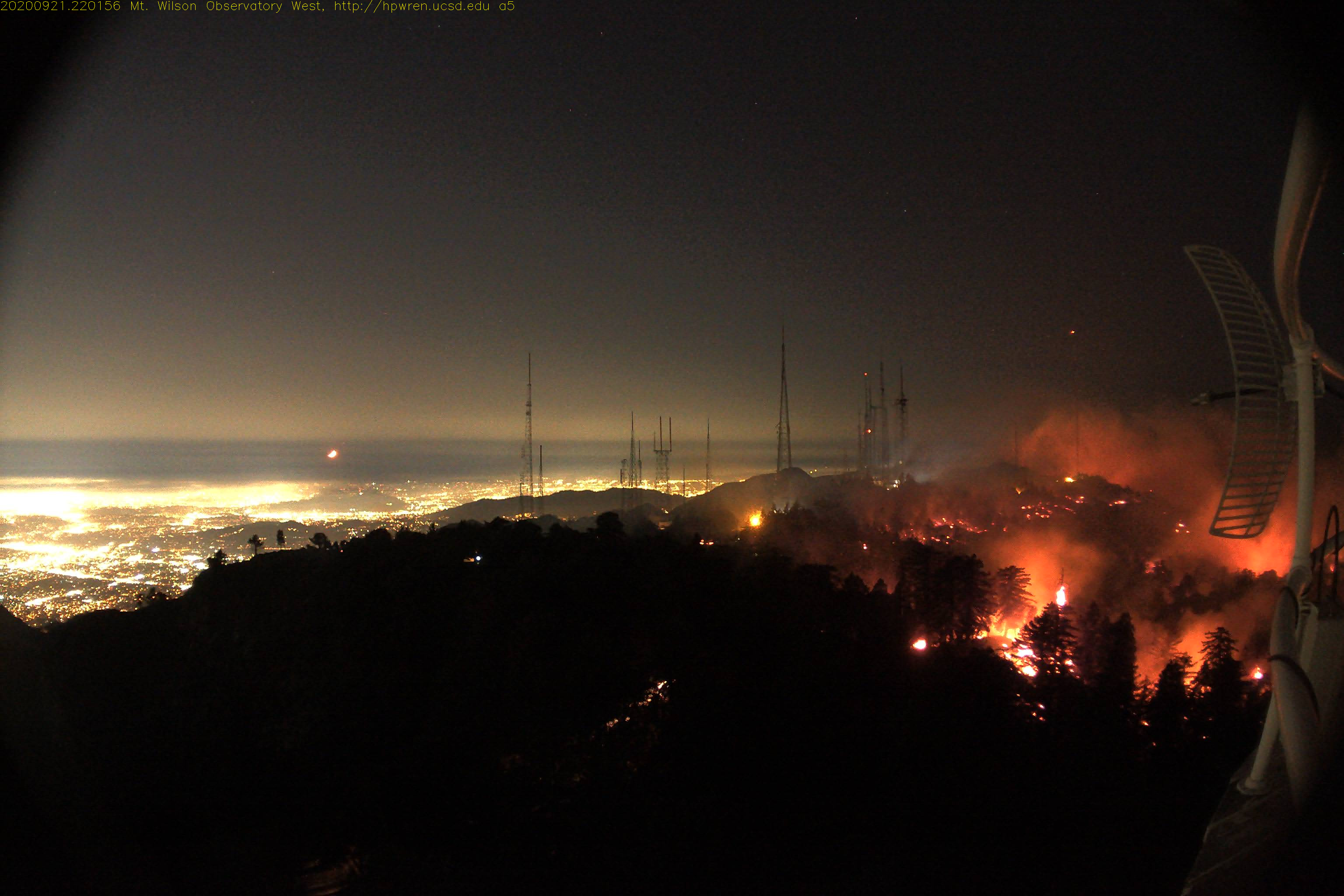
When the fire started at Cogswell Dam on September the 6th, the weather conditions were concerning but favorable as the high temperatures and low humidity were prime conditions for the spread of fire, but the prevailing winds were from the south or the east which would move the fire north and west into the San Gabriel wilderness between the San Gabriel Valley to the south and the Angeles Crest to the north. Due to the proximity of the fire, the observatory was evacuated for the safety of the residents and employees. During the next few days, the fire smouldered along the western front, and seriously expanded to the north and east driven by the wind with the largest expansion in the first 2 days after ignition. During this same time, a significant number of fire fighting resources were involved in at least two other fires in the southern California area and many others along the west coast. Starting on September 10th, the fire started encroaching on the last ridge to the east of us, mostly patchy and slow moving. The bulk of the fire movement and fire fighting resources during this time were devoted to protecting the homes and buildings in Monrovia and Duarte to the south as the winds had shifted to push the flames to the south. Starting on Sept 11th, the fingers of the fire crossed over the top of the final ridge into Big Santa Anita Canyon. The fire growth was patchy and slow but steadily moving down the slope. As of the morning of Sept 13, the fire has reached the bottom of the canyon in spots and is threatening to run up the canyon slope to the summit where the Mount Wilson Observatory and the TV transmitters are located. The bulk of the fire fighting action is being positioned to keep the fire from advancing further up the canyon wall.
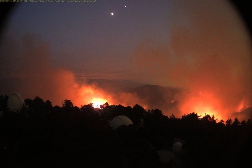
Update - 2020 Sep 14
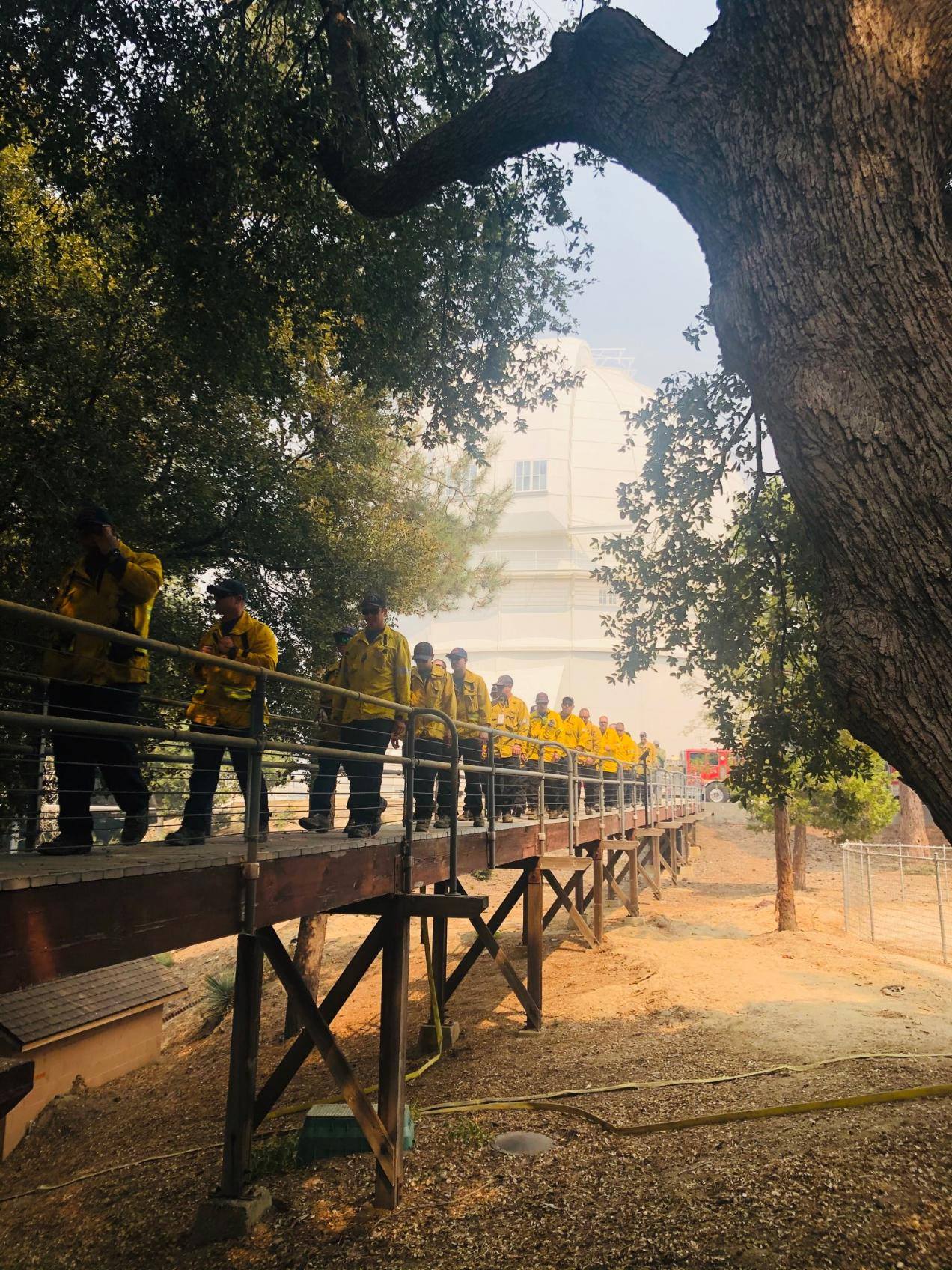
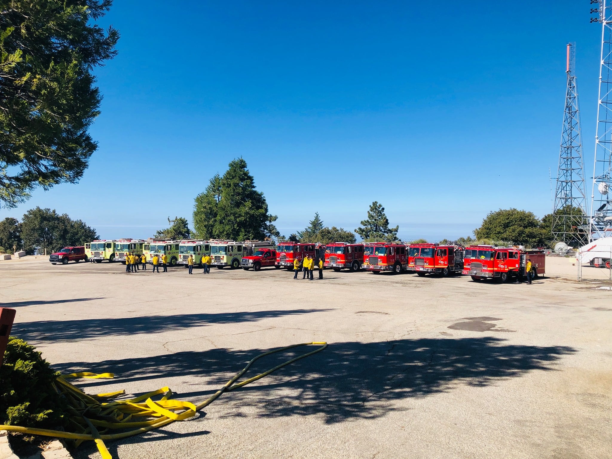
During the evening of Sept 13th, an LA County Fire Department Strike Team arrived on site for structure protection. There are currently fire engines and crew stationed at the Observatory from many different agencies in LA County and across CA. Larry Webster (CHARA Array site manager), Craig Woods (CHARA Array assistant site manager), David Cendejas (Mount Wilson superintendent), and John Stone (Mount Wilson grounds maintenance) remain onsite to assist the firefighters with preparing the observatory and providing critical information and access to water tanks, hydrants, and other infrastructure.
A letter from Sam Hale, Chairman of the Board of Trustees for Mount Wilson Institute, discusses the current fire situation and the work that's been done over the years to keep the mountain as safe as possible from fire.
The four remaining observatory staff members evacuated the mountain in the evening of Sept 14, as over a dozen fire engine crews stayed on the mountain to battle the blaze.
David Cendejas reported, "Before evacuating, Mill creek hotshots went over their plan to start a backfire down by Mt.Harvard in order to gain a controllable advantage while conditions were within their favor. At the time, the fire was coming in from the Eastern, Southeast flank of the mountain and was within a mile of proximity to the Observatory grounds. After speaking with Strike team Batallion Chief Stan Brawer, he reassured that our part in aiding them was complete and that all fire personnel who came in would be briefed of the mountain emergency protocols and procedures."
An aerial video in IR and visible shows the location of the fire in relation to the observatory.
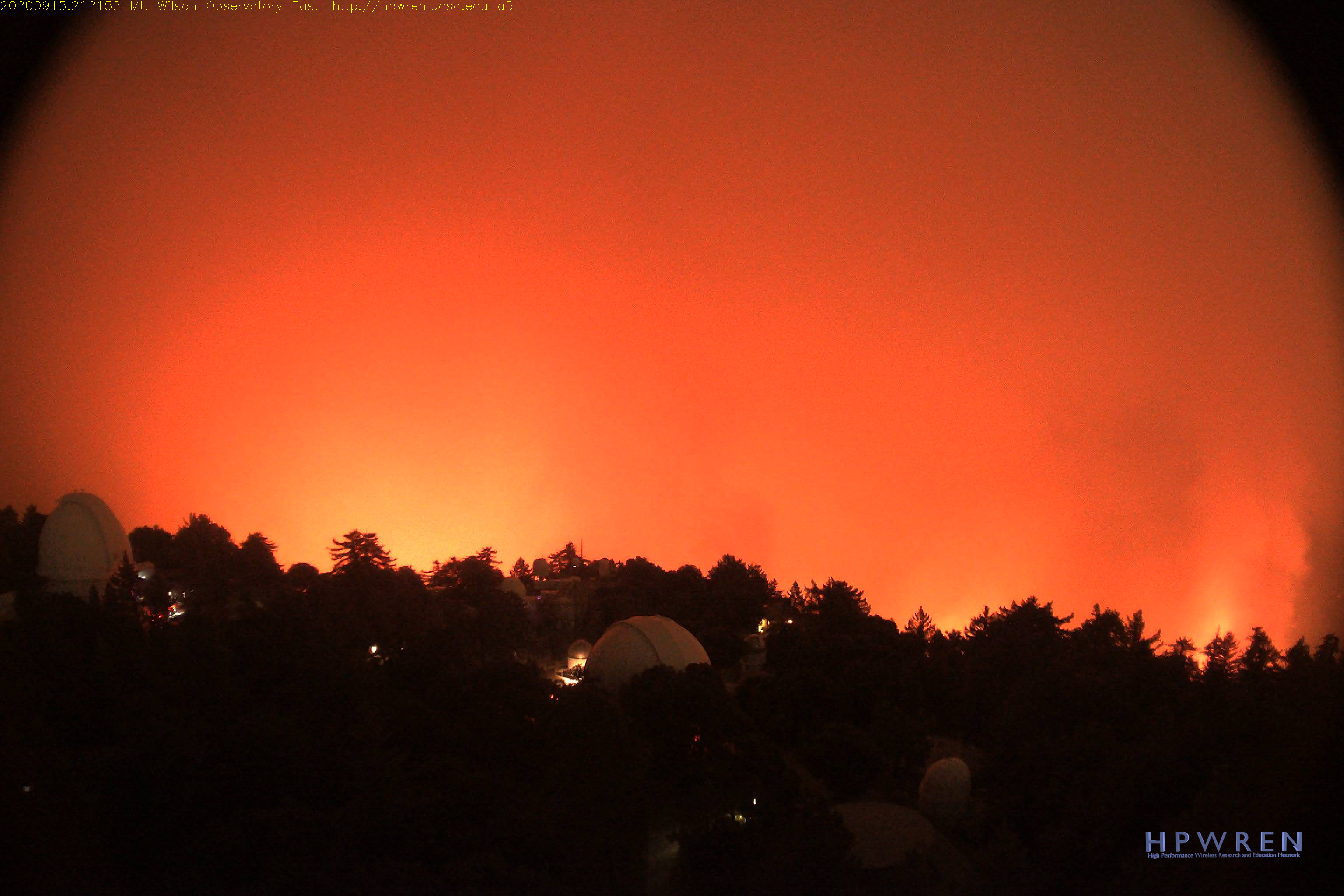
Update - 2020 Sept 15
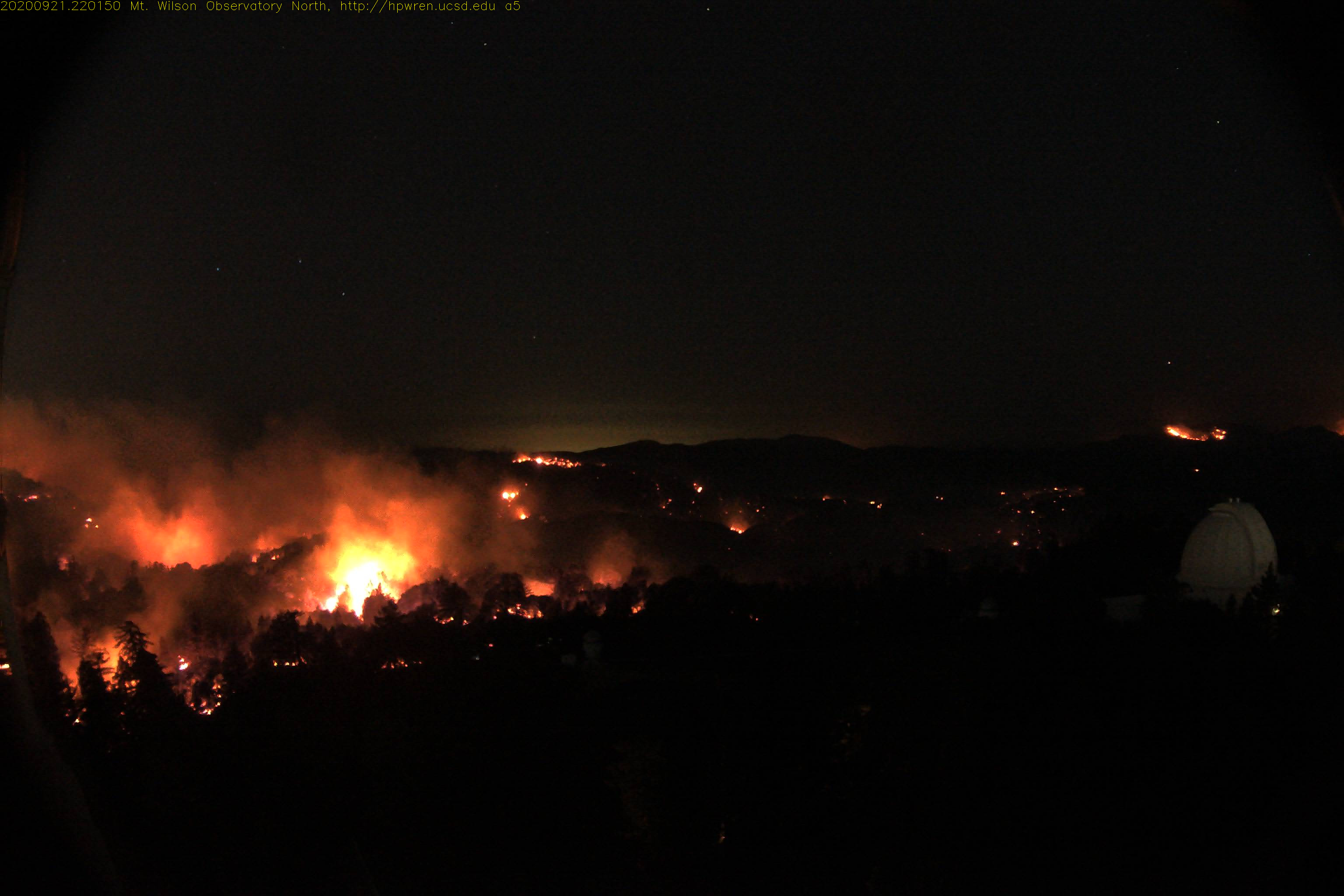
Firefighters worked diligently through the night with a focus on protecting Mount Wilson and the foothill communities. The fire reached within ¾ to ½ mile of the observatory yesterday, but has not yet reached the summit of the mountain. They are expanding efforts to reduce the growth of the fire and are conducting strategic burns and using aircraft to support ground resources as weather and conditions allow.
At 12:30 pm, the Angeles National Forest reported on Facebook that the fire was within 500 ft of Mount Wilson Observatory and that crews are in place to receive the fire.
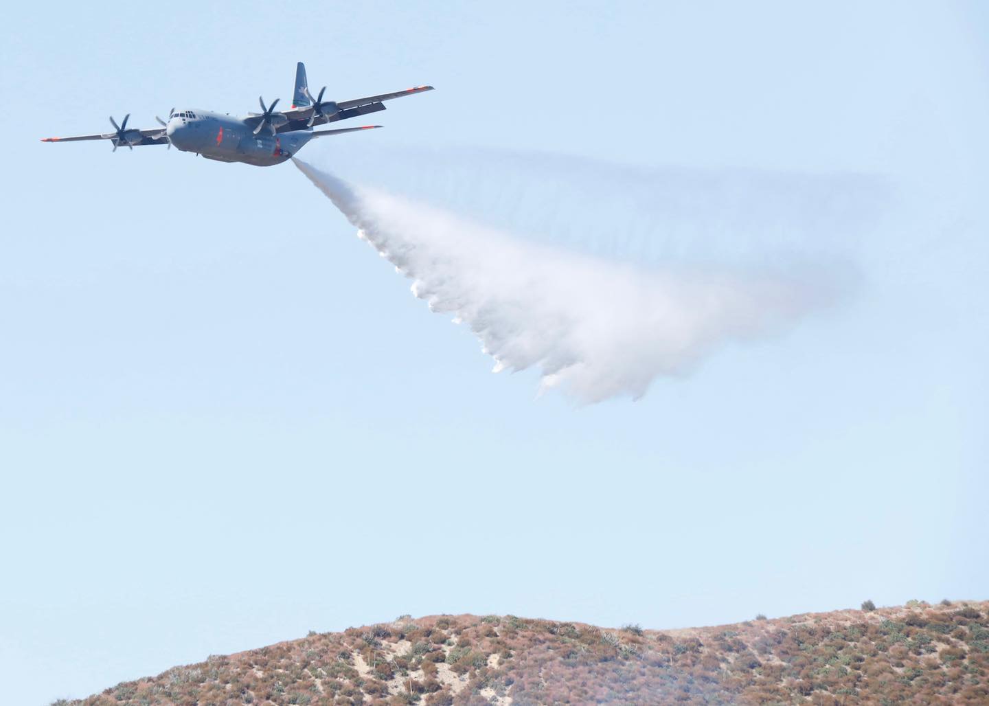
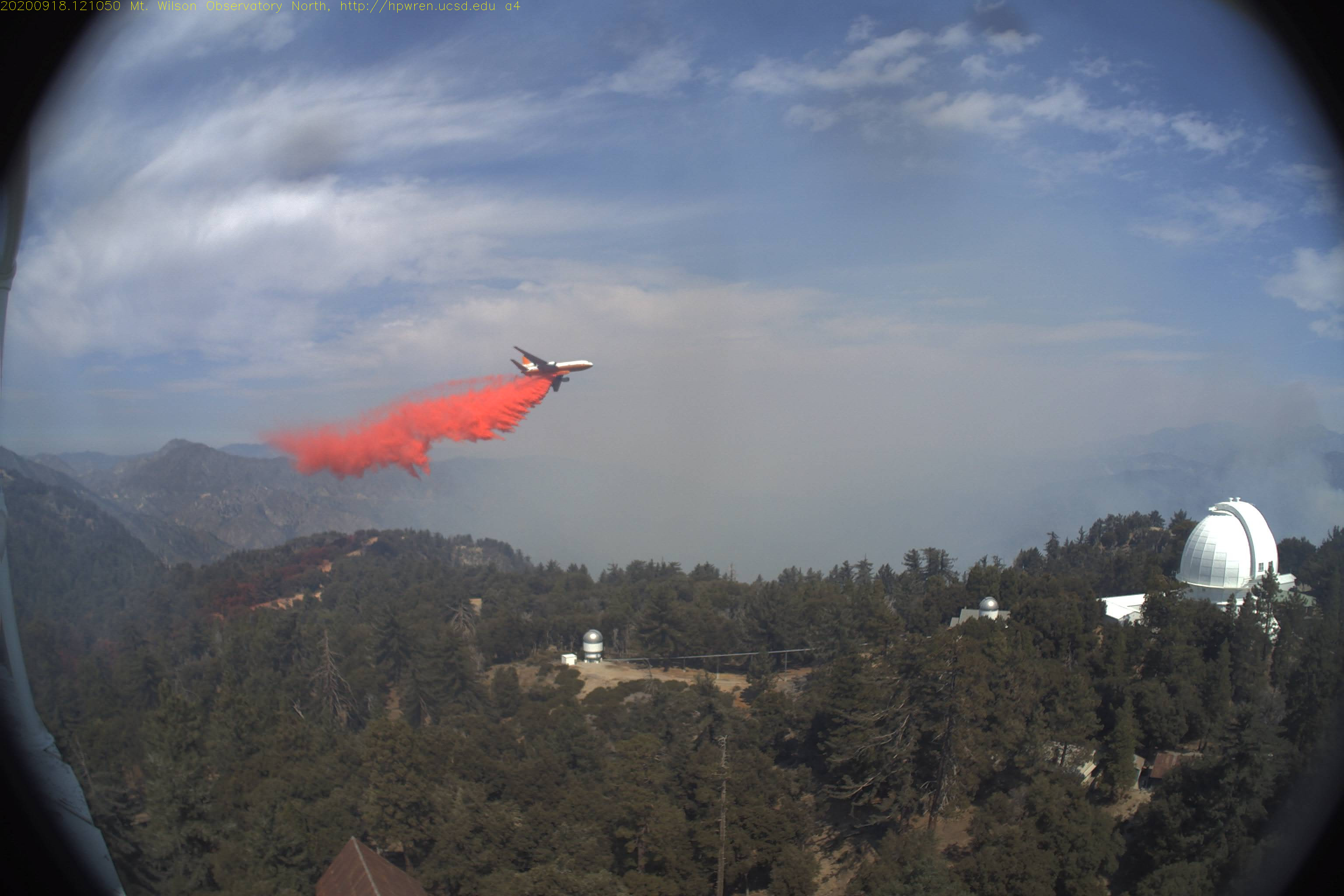
The evening InciWeb report mentions that "firefighters worked diligently to protect the infrastructure around the Mt. Wilson Observatory by using strategic firing operations in conjunction with aviation assets to strengthen dozer lines. Additionally, prior fuel treatments done around Mt. Wilson helped moderate fire intensity and rate of spread around the area." A C-130 from Sacramento equipped with a MAFFs (Modular Airborne Firefighting System) made drops near Mt. Wilson.
A Facebook post from the Angeles National Forest stated, "While there is still much work to be done in southwest and in the northern sections of the fire, your firefighters did incredible work around Mt. Wilson today. Assisted by the outstanding defensible space of Mt. Wilson Observatory, firefighters installed hand and dozer line - strategically fired, and dropped water creating a strong protection point for Mt. Wilson."
A recording of the evening operational update from the Incident Management describes positive progress on efforts to fight the fire.
Update 2020 Sept 16
The observatory is still standing. Thanks to the amazing work of the fire fighting crews, the protection lines appear to be holding. Based on the HPWREN cameras, it looks like the fire is still very active nearby Mount Wilson.
The InciWeb morning report states, "Today focus of our efforts will be to hold onto what has been accomplished over the last few days in the vicinity of the foothill communities and Mt. Wilson Observatory. Firefighters will be working on strengthening the lines and looking for opportunities to attack the fire directly. Additional strategic firing may occur as necessary to secure the lines." With fuels at critically dry levels they anticipate increased fire activity over the next couple of days.
KTLA 5 News posted a live fly over of the observatory in the afternoon.
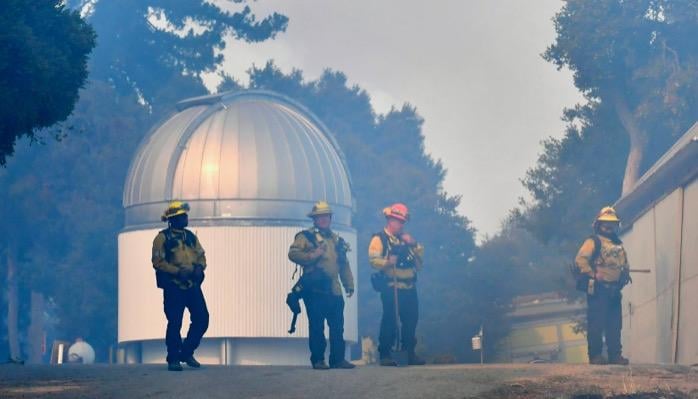
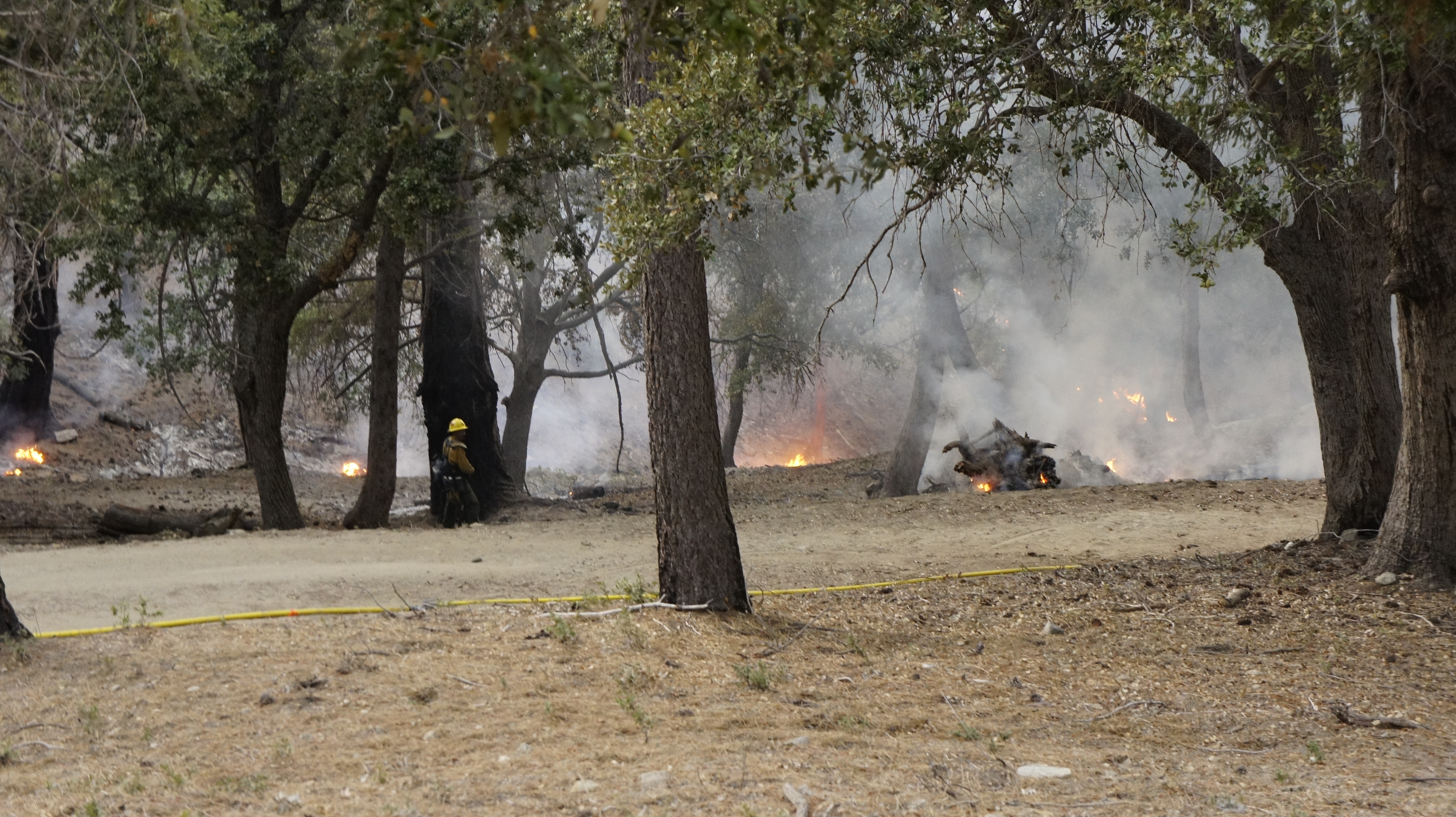
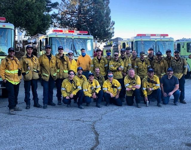
 Many thanks to the firefighters on the ground working to defend the observatory. These photos were posted on Facebook by the Mount Wilson Observatory on Sept 13 (left) and Sept 15 (right).
Update 2020 Sept 17
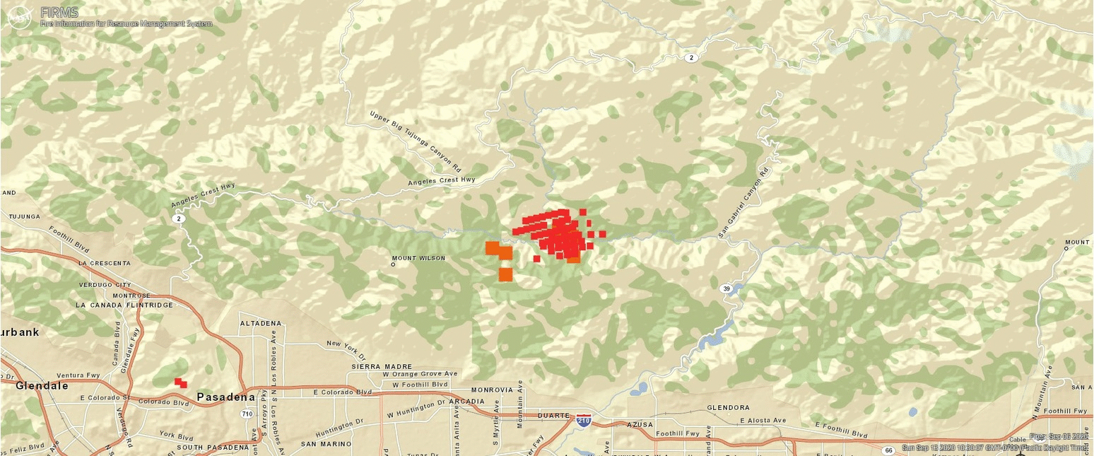
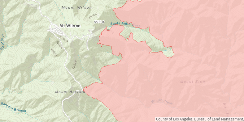
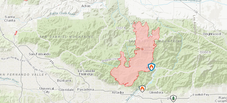
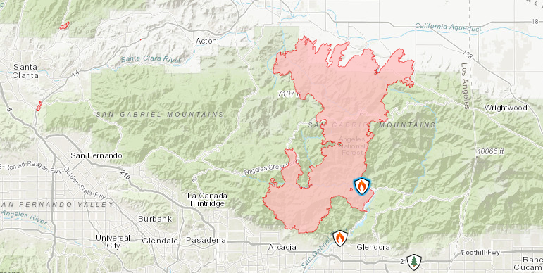
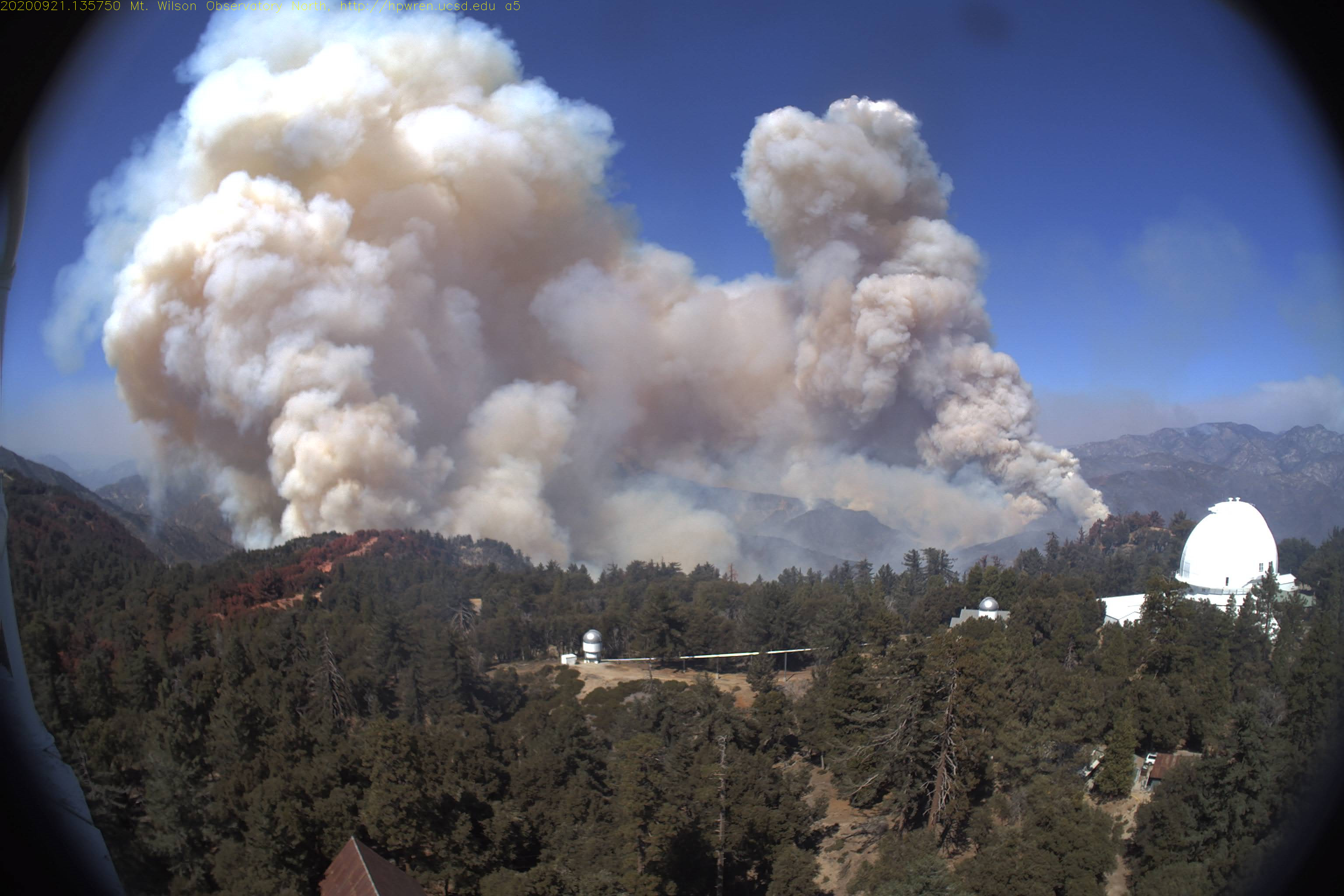
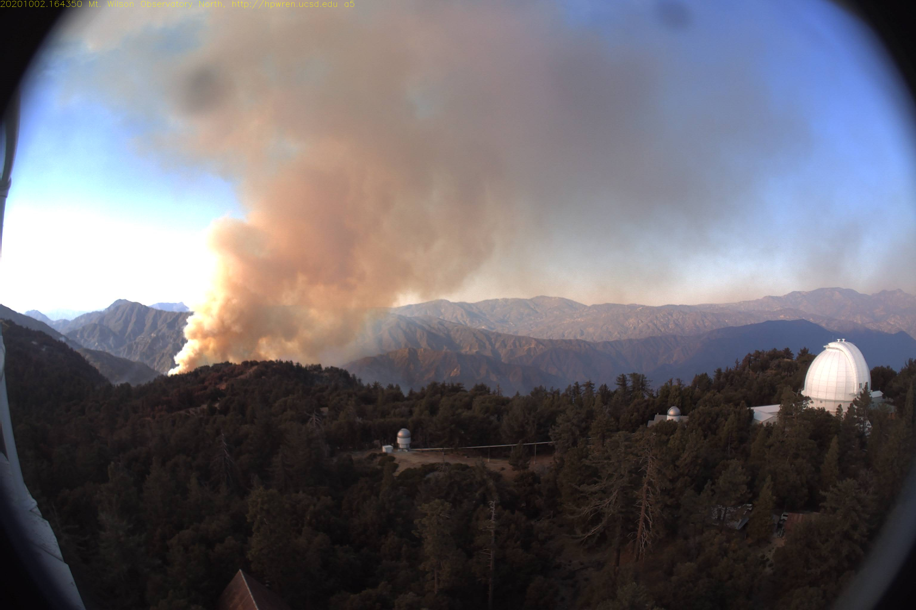
As of this morning, the Bobcat fire has expanded to 50,539 acres with only 3% containment. The fire now extends from the foothills near Arcadia in the south, has crossed the Angeles Crest Highway 2 near Mount Waterman and Hwy 39, and is heading north toward Juniper Hills in the Antelope Valley. The fire is still active near Mount Wilson. Based on the HPWREN cameras during the night, there appeared to be some additional smoke plumes moving northward and in the south.
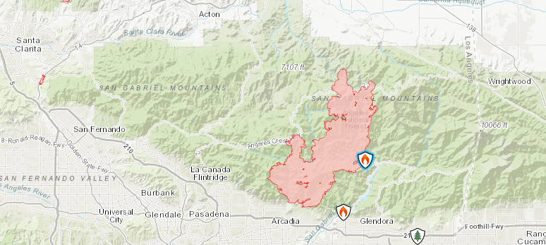
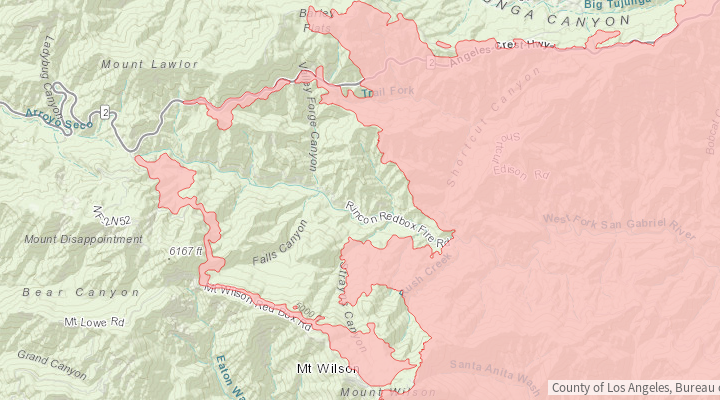
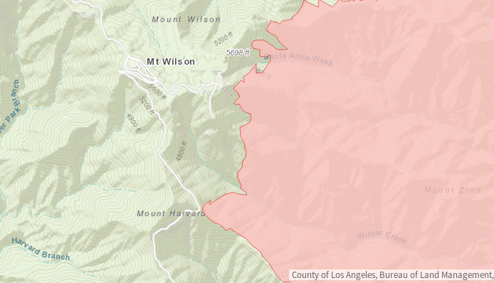 Maps showing the Bobcat fire boundaries from InciWeb on the morning of Sept 17. One panel shows the wide field of the San Gabriel mountains and another is zoomed in near Mount Wilson.
During the Morning Operational Briefing on Sept 17, Kerri Gilliland, Planning Operations Trainee for California Incident Management Team 1 said, "We did have significant fire behavior up towards Mount Wilson last night. It was taking timber stringers or brush, pushing up towards Mount Wilson. We had aviation and crews and engines in there throughout the evening." They will continue to monitor the situation and will continue to have firefighters working on the ground.
Around 9:30am, there appeared to be a flare up near the south ridge of Mount Wilson, with thick smoke visible in the east and south facing HPWREN cameras. Helicopters could be seen dropping water in the area. Later in the afternoon, CHARA site manager Larry Webster heard discussions on the Forest Service radio about the successful "Firing Operations" on Mt. Wilson, so it seems that the smoke seen on the observatory grounds earlier in the day was probably the result of controlled burns to strengthen defense against the advancing fire.
This evening, the Projected Incident Activity section on InciWeb reports, "Fire activity ringing around the eastside of Mt. Wilson Observatory is threatening all of the values on that peak."
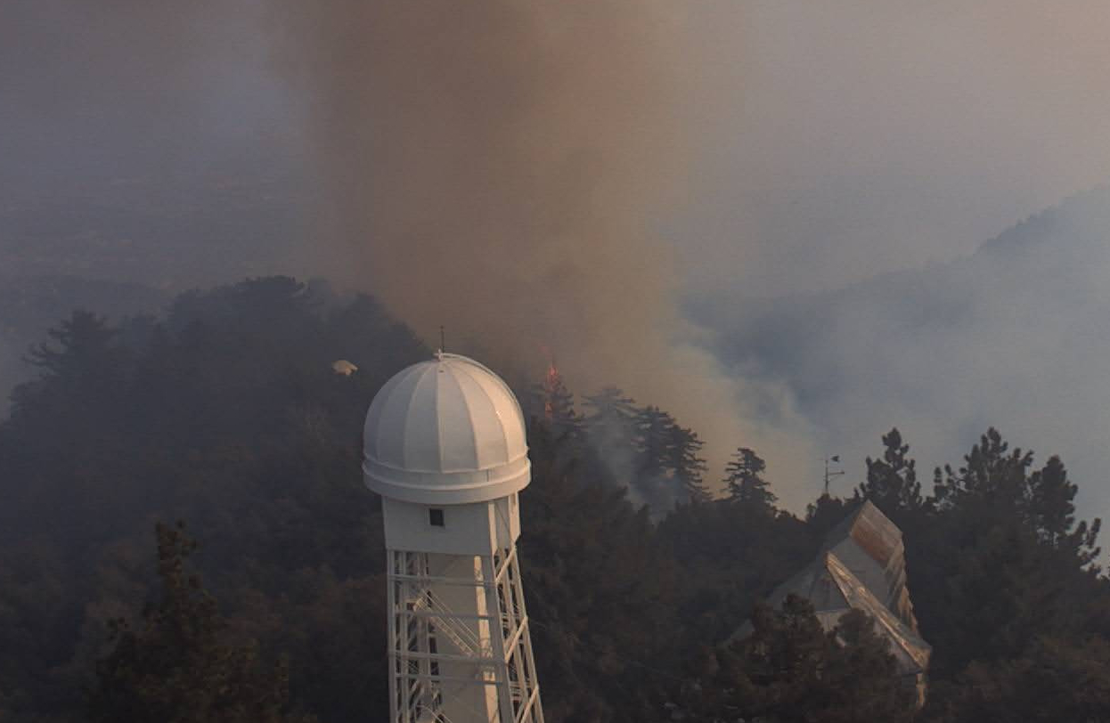
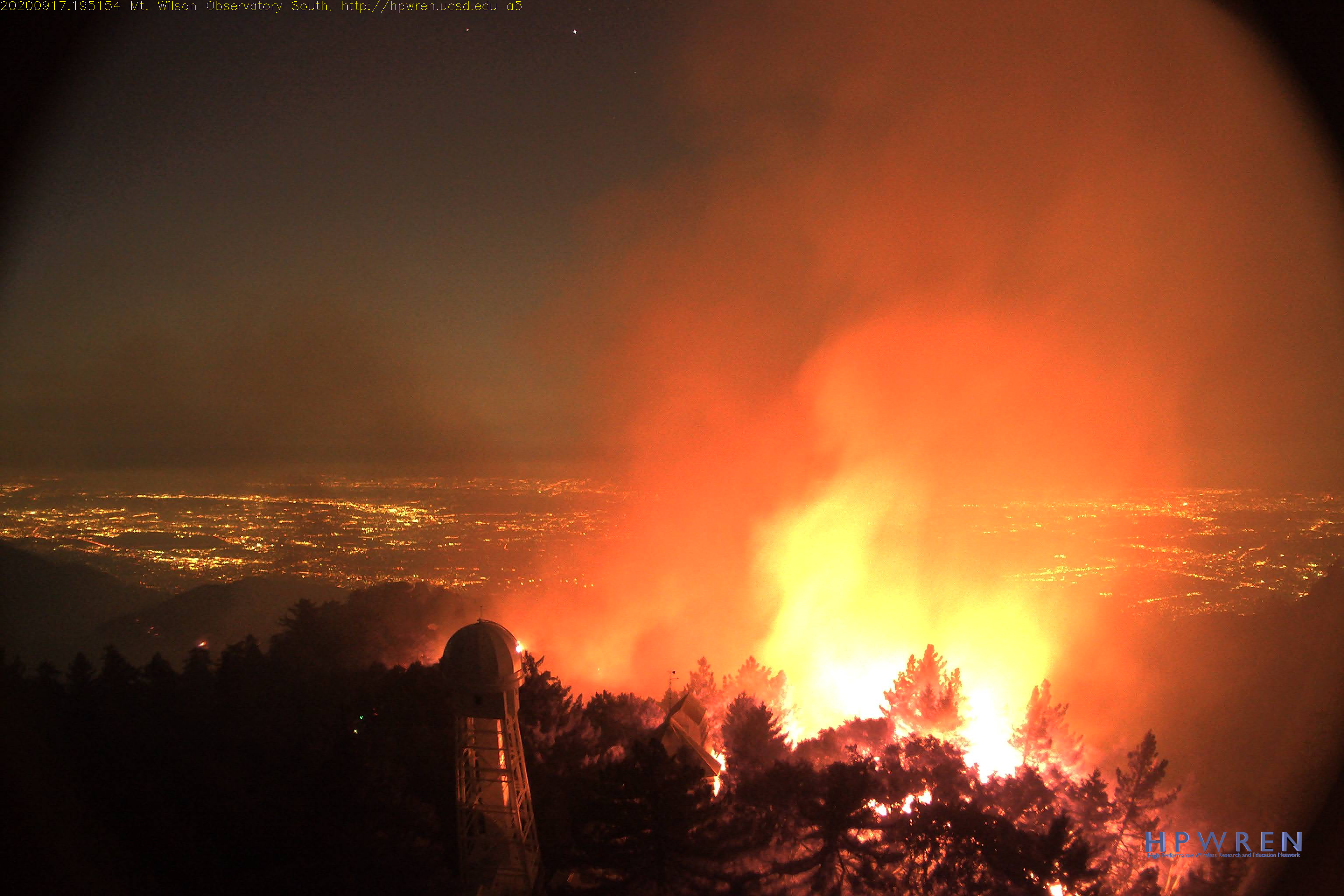
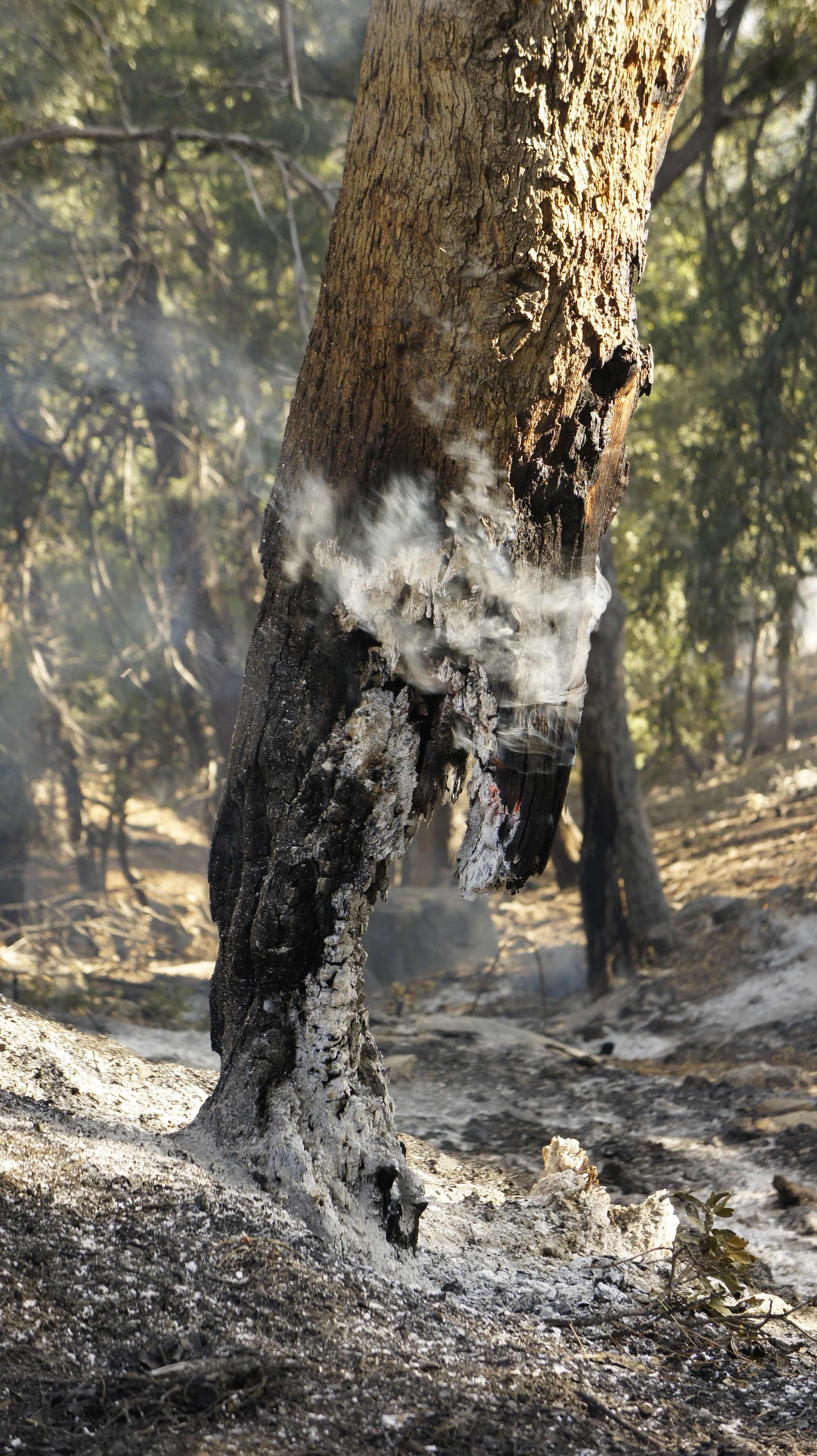
The photo above shows a tree catching fire on the southern edge of the observatory grounds. It was extinguished within a few minutes. It is not clear whether this was the result of strategic burning or whether the fire has reached the observatory. During the Bobcat Virtual Meeting held in the evening of Sept 17th, officials confirmed that Mount Wilson continues to be an issue. They reported that resources on the ground are reinforcing the lines and that the structures are in good shape. During the Q&A, Unified Command leader Jerry McGowan stated that they don't expect the fire to go over the top of Mount Wilson, however, there is still the possibility that it will go around the mountain.
As of 7:30 PM, the webcam images showed fire on the grounds of the observatory near the southern ridge. Superindentent David Cendejas believes that the crews might have started a backfire by the library and snow telescope. CHARA night-time manager Chris Farrington noted that none of the trees in the foreground were catching fire and it seemed to progress in a controlled manner. So this could be an intentional backfire to strengthen the perimeter around the observatory. The bright flames seem to be progressing around the southern rim toward the west.
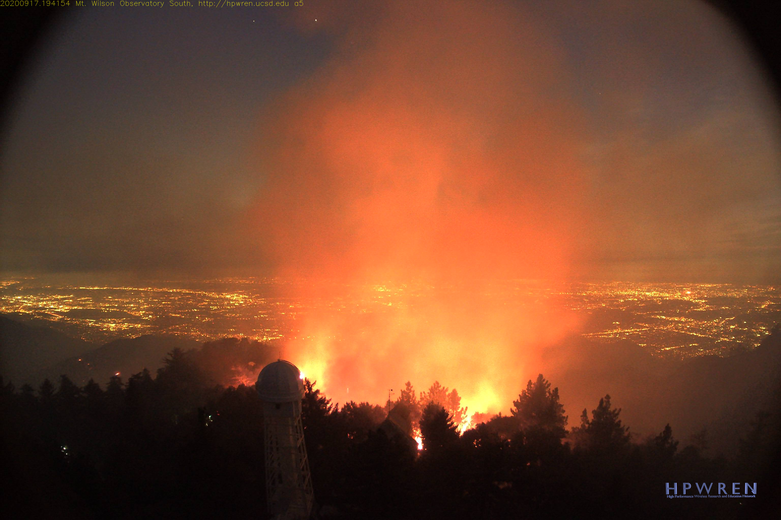
 Observatory grounds from the south facing HPWREN camera on Sept 17 at 7:45 PM and 7:54 PM. This was a strategic burn to strengthen the perimeter.
During the Evening Operational briefing on Sept. 17, Kerri Gilliland reported significant fire activity near Mount Wilson and that a lot of good work was being done to hold the existing line. She said, "It was picking up in some of the timber stringers in the brush, making uphill runs toward Mount Wilson." They will have resources on the mountain throughout the evening.
Update 2020 Sept 18
Early this morning, the HPWREN cameras showed the sun rising above the mountains, with a few visible patches of fire burning on the steep, south-facing slopes below the main parking lot of the observatory. An LA Times article confirmed with Angeles National Forest personnel that the flames seen close to the observatory last night were from controlled burns "being used to expand containment lines."
The Bobcat Fire is at 60,557 acres and the containment has increased to 15%. The Angeles National Forest posted that Mount Wilson is still safe. The firefighters will continue to focus on the north end of the fire where evacuation orders were issued for Juniper Hills, Devils Punchbowl, and Paradise Springs in the Antelope Valley yesterday.
Site manager Larry Webster listened to the morning briefing from the fire service and reported that "things are looking pretty good for the Observatory and Mt. Wilson. There is still concern about the fire snaking around the West Fork canyon to our North, but it seems they are happy with their successful backfiring operations. Winds are expected to increase this afternoon -- always an unpredictable factor."
The interactive map on the InciWeb page shows the fire boundary along the eastern ridge of the observatory and crossing the southern most road heading down to the monastery. There are no reports of damage to any structures and conclusions should not be drawn based on the location of the boundary line. It's possible that the boundary lines follow the work of the strategic burns done on the grounds of the observatory yesterday. The map emphasizes the heroic efforts of the firefighters who are working under difficult and dangerous conditions to protect the observatory. We are all very grateful to the fire crews working throughout the region.
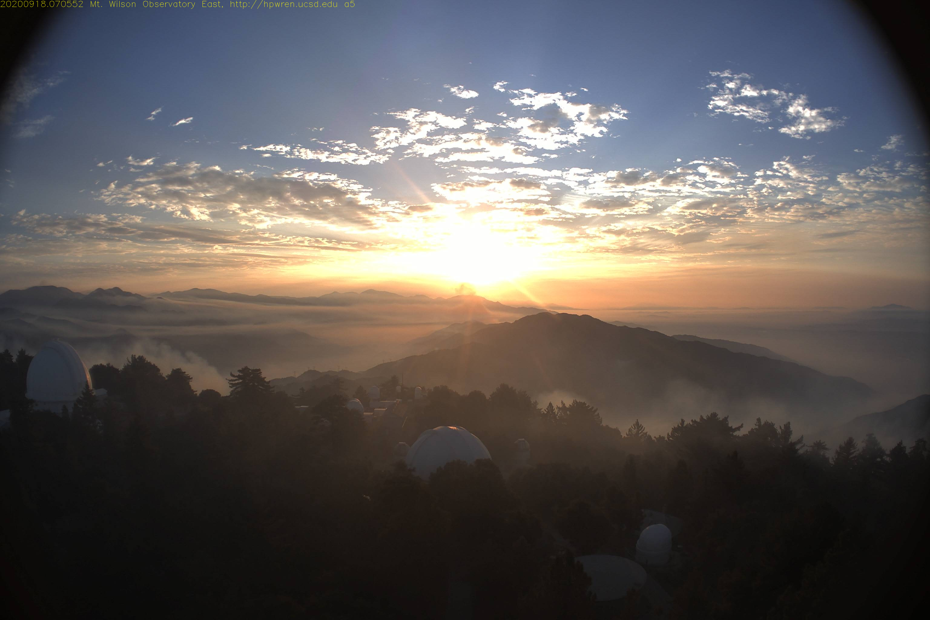
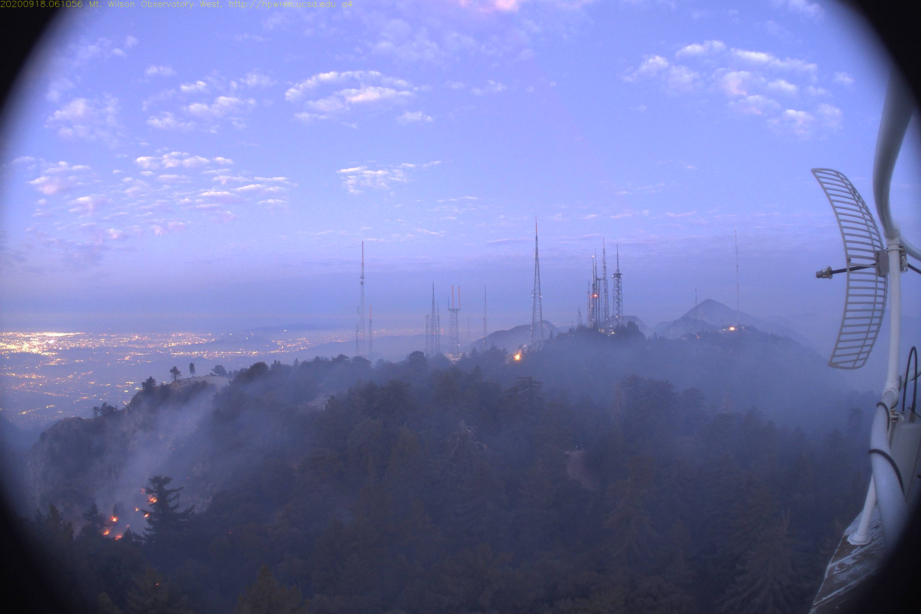 HPWREN cameras on Mount Wilson on Sept 18 looking east at 7:05 AM and west at 6:10 AM.
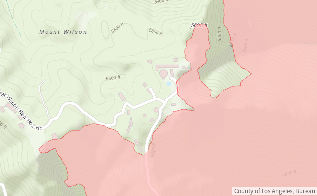
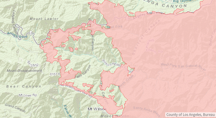
 Maps showing the Bobcat fire boundaries from InciWeb on the morning of Sept 18. One panel is zoomed in near Mount Wilson showing the location of the observatory buildings and transmission towers and the other is a wide field of the San Gabriel mountains.
The webcams show a much calmer scene around Mount Wilson tonight, although the red glow of fire can be seen farther in the distance toward the north and in the east. During the day, aircraft placed retardant around Mount Wilson to strengthen the lines and keep activity in check. While the observatory appears to be safe for now, the fire is spreading rapidly in the north, driven by strong winds, where it is threatening the desert communities in the Antelope Valley.
Update 2020 Sept 19
As of this morning the Bobcat fire is now at 91,017 acres with 15% containment.
In a letter sent on Sept. 18, 2020, Sam Hale, Chairman of the Mount Wilson Institute Board of Trustees, expressed deep gratitude for those working on the ground and in the air to protect Mount Wilson. He wrote, "We owe our very existence to the firefighters on the ground and the helicopter pilots. They are our heroes. They are true professionals, artists when it comes to the use of 'strategic firing.' We will be forever thankful for the 12 crews, some forty to fifty firefighters from all over, who defended our home, risking their lives defending our scientific treasure. The fire is still burning on the northern and southern flanks, where fairly recent fires, in 2009 and 2017, have reduced the fuel load. We are still not completely out of the woods, so the crews will stay on the mountaintop to the end of the month or longer to protect the site from flair ups. Today, tanker planes dropped fire retardant that will further secure the area."
A time-lapse video shows the strategic burn operations on the night of Sept. 17.
Larry Webster, Craig Woods, and David Cendejas returned to the mountain today to assist with some maintenance issues. Superintendent David Cendejas reports that no structural damage has occurred at the observatory and all water, electrical, and internet systems are intact and operating normally. Larry Webster reports that the E1 dome of the CHARA Array is a shade of pink; he will do a more complete assessment of the CHARA facilities with approval and coordination with the crews on the ground.
During the day, handcrews were working to create defensible space around structures.
Update 2020 Sept 20
The strategic burn of last night went well. During the day, the Santa Fe hotshots continued to use the hose lay to extinguish burning logs. Larry Webster and Craig Woods were able to inspect the E1 and E2 telescopes of the CHARA Array and reported no damage to the domes, bunkers, or light pipes.
Observatory staff focused on transferring and filling up the water tanks on the mountain.
The fire continues to be active north of the Observatory down in the canyon by the West Fork San Gabriel river, on the south facing slope below the Angeles Crest Highway. A big plume of smoke could be seen in the north facing HPWREN cameras during the day with intense flames visible at night. Currently the winds are pushing the fire north toward Highway 2. The fire crews on the mountain left to join the fight against the flare up during the day and a large number aircraft made aerial drops, including a 747 supertanker. Several engines returned to the mountain later in the afternoon to continue protecting the observatory.
As of this evening the fire was at 103,135 acres and 15% containment.
 Maps showing the Bobcat fire boundaries from InciWeb on the evening of Sept 20, 2020. One panel shows the wide field of the San Gabriel mountains with significant northward advance of the fire into the desert communities of the Antelope Valley. The other is zoomed in near Mount Wilson showing the perimeter created around the observatory through the strategic burning operations.
Update 2020 Sept 21
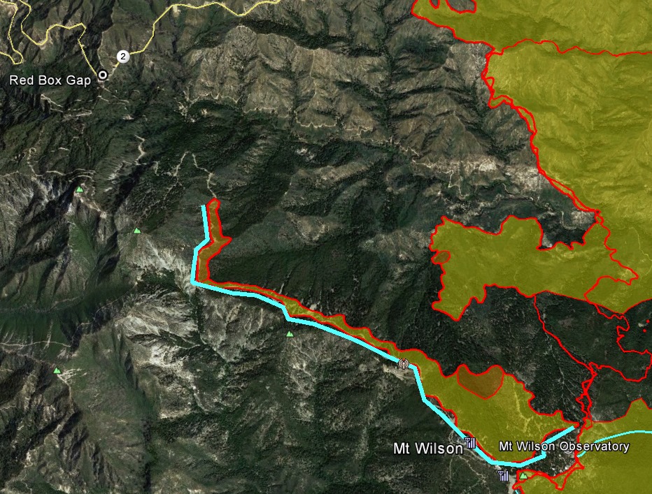
The fire in the West Fork canyon continues to be active. After dark last night, there was concern that the fire might make a run toward the observatory, so an additional 20+ engines arrived on the mountain top to protect structures at the observatory and the transmitter towers. The three civilian support members were briefly evacuated to the front lower parking lot. The threat subsided shortly after the additional engines arrived.
During the day, a majority of the engines made their way down to another drop zone to focus on making sure the fire doesn't wrap around the north west side of Mount Wilson toward Redbox Rd.
At 1:40 pm, David Cendejas reported that the fire toward the north picked up again and is making its way towards the northwest slope of the Mount Wilson drainage. About an hour later, Craig Woods reported that they started another strategic firing operation on the north/northwest slope of Mount Wilson, beyond the W1 telescope of the CHARA Array. The three civilian support members were again evacuated to the lower parking lot.
Additionally, there are spot fires in the Upper Winter Creek canyon on the southwest side between the observatory and Mount Harvard that are being closely watched. There is concern that they might push to the top and over the side into Eaton Canyon.
 Glow of the strategic firing operations near Mount Wilson during the night of Sept 21, 2020 at 10:02 PM looking West and North in the HPWREN cameras.
Update 2020 Sept 22
The strategic firing operation conducted by the Hotshots on the north side of the mountain yesterday went as planned. The burn went west from the E2 telescope toward the front gate. The fire crews continued to lead the backfire down Mount Wilson Redbox Rd during the night. Calfire had over 150+ personnel on the line making sure the backfire did not get out of control. This will help tremendously in preventing the uncontrolled fire in the canyon from overrunning the observatory. David Cendejas reports, "These firefighters have been amazing and persistent in securing our Mt.Wilson Peak with these strategic firing operations. We truly owe them the world!"
Throughout the night and into this morning, small ground fires were burning everywhere. Today the hope is that the winds remain calm and they can continue to burn off all of the dead debris around the observatory. The relative humidity went up last night and remained in the 40% range all night long.
The fire has used up about half of the 530,000 gallon fire water supply. Before the strategic burn began yesterday, Larry and Craig were able to go down to the wells and fix two malfunctioning pumps. At the end of the day they discovered a small net gain of water in the fire tank.
Larry and Craig were able to inspect the E1, W1, and E2 telescopes of the CHARA Array. There is a dusting of ash and debris in the domes of E1 and W1, but far less than they were expecting, which is great news. The E2 telescope also looked relatively clean, but there were a lot of large ash flakes around the gaps between the cylinder floor and the dome support legs.
The strategic fire operations will continue throughout the day. The plan is to continue the backfire burn along Redbox Rd. until it meets with Highway 2. Officials expect to complete the operation to secure these defensive lines later today. Crews continue to mop up the area after the burn.
Time lapse videos show the strategic burn operations in the north and west facing HPWREN camera on Sept 21, 2020.
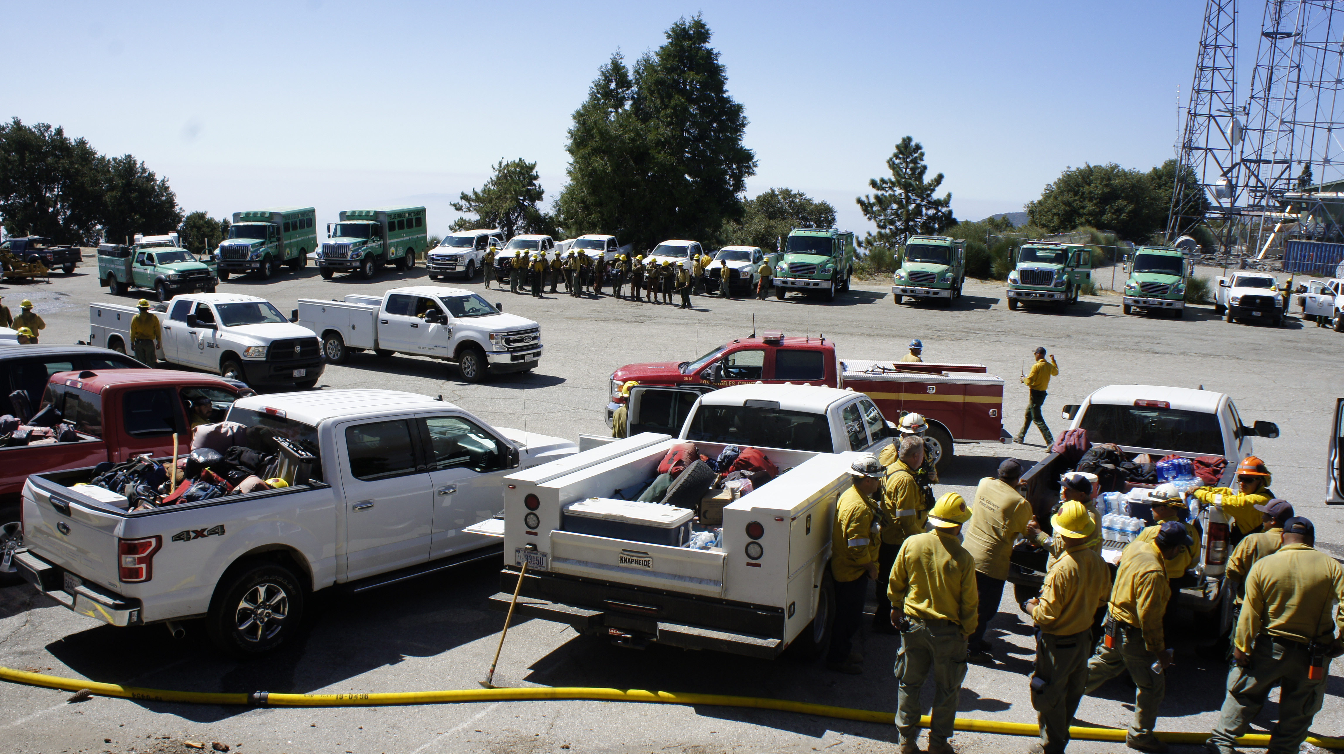
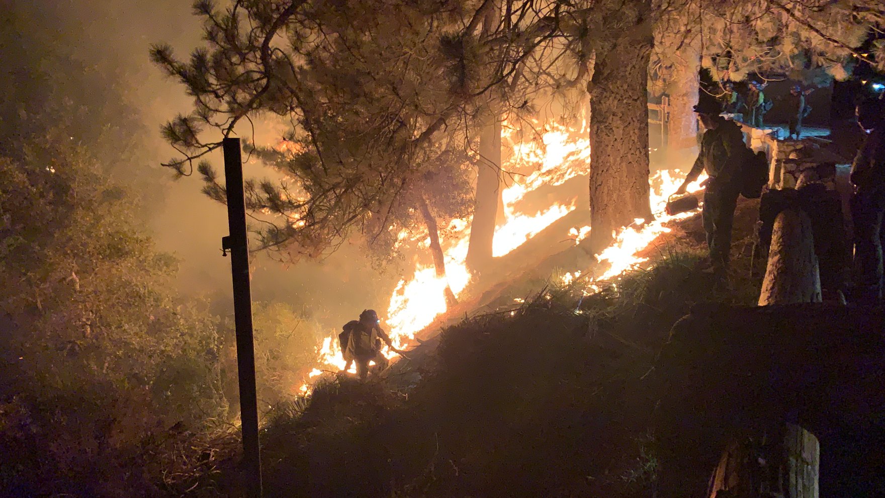
 Firefighting crews onsite to protect the observatory during the strategic firing operations on Sept. 21, 2020. Also shown is a photo of the burn in progress on the observatory grounds.
Update 2020 Sept 23
As of this morning, the fire is currently at 113,307 acres and containment has increased to 38%.
Yesterday, the strategic firing operations continued on Redbox Road, adjacent to the television towers and beyond. The Bobcat Fire still seemed to be burning in the canyon below, but with less intensity than the days before. The relative humidity might have moderated the spread. LA county fire continued mopping up hot spots and patrolling the observatory grounds.
Last night was rather quiet on Mount Wilson with reduced structure protection by the fire departments. Firefighters completed a critical strategic firing operation overnight, strengthening the containment line connecting Mount Wilson to Highway 2. The efforts on stopping the fire along the road and at Red Box seem successful, but more backfiring will be done in the area to secure it. Today, the firefighters are looking to add some depth in the containment lines.
Larry and Craig are working to fix intermittent well pump problems, both with the Observatory and Forest Service pumps. The ground burn shorted out the 3-phase electrical feed to the Forest Service pump. On their way down to the wells to make the repairs, they found a mid-sized Oak had fallen on the road blocking it completely. They also discovered a 60-ft tree almost half burned through right next to the road, with a serious danger of falling. They informed the Fire Chief, and he is working on finding a solution to clear the road so that they can bring the truck and tools down to work at the well. There is still sufficient water stored in the tanks for the time being.
Update 2020 Sept 24
The afternoon and evening were fairly quiet on the mountain yesterday. There were a few spot fires during the night on or near the observatory grounds that were taken care of by firefighters on the scene.
During the Daily Operational Update yesterday evening, Kerri Gilliland reported that they completed the firing operations near Mount Wilson and tried to get additional depth to the lines, however, "we had adverse conditions and it was blowing embers and smoke across the line so resources held this portion all the way out to Red Box and out to the 2 and they mopped everything up."
Yesterday Larry located someone who was able to fell the dangerous tree near the road down to the well. Today, Larry and Craig will repair the damaged Forest Service well pump caused by the ground fires on the north side. This pump is a crucial resource for the fire fighting effort. It supplies all of the water to the three fire hydrants at the lower parking lot, and one by the TV stations as well. Now that the downed and dangerous trees have been removed, they can access the wells by vehicle again.
Larry reports that while things seem quiet at the moment, there are hundreds of little fires burning on the grounds and in the canyons on the north side. Any strong wind event could fan these fires into something big in an instant, and would again become a real and direct threat to the observatory. Crews continue to be stationed on the mountain.
The morning incident report states, "The areas where strategic firing took place north of Mt. Wilson will continue to burn out today and if needed and conditions warrant aerial ignition will be used to increase the depth along Highway 2."
The fire is currently at 113,986 acres and containment has increased to 50%. Fire activity has moderated and only 253 acres were added overnight. Most of the containment is along the southern and northern boundaries of the Bobcat fire.
During the day, Larry and Craig attempted to repair the damaged power feed to the forest service well, but were unsuccessful due to very dangerous conditions. Heat from the fire shorted the 3 phase electrical feed somewhere along the long length of the conduit to the pump, but under the current conditions, it was not possible to locate the fault. The well head's electrical feed also suffered heat damage. There is still active fire in the area, with rocks and debris falling down the steep canyon where the well head is located. They also heard another large tree fall somewhere nearby. There is currently 130,000 gallons of water in the Forest Service tank on the hill (270,000 gallon capacity).
The Mount Wilson water tank is at 250,000 gallons (half full).
Later in the afternoon Chief of the US Forest Service, Vicki Christiansen, arrived with a group of people to visit Mount Wilson. District Ranger Jerome Perez gave a rundown of the Observatory's long relationship with the Forest Service and Larry Webster gave a tour. They stopped by Echo Rock to look over the fire, visited the dome of the 100-inch telescope, and learned about Georgia's State University's operation of the CHARA Array.
In the evening, Larry reported that it remains relatively quiet on the mountain, mostly due to calm wind conditions. Fire is still burning all over the north facing grounds and canyons, but with low intensity. There are only a few engines on site tonight. The Fire is still raging near the Red Box area, but has not yet crossed the parking lot into the west drainage, so the firefighters appear to be holding the line.
2020 Sept 25
There was nothing significant to report overnight. Many little ground fires are still burning on the north side. Activity for the firefighters in our local area will be around Red Box.
The morning update on InciWeb reports that "Crews will continue to prep and add additional depth to secure lines north of Mt. Wilson and in the Northeast between Highway 2 and Big Rock Creek. These continued strategic firing operations are done to secure the fires perimeter from the fire making a run at the fire lines from unburned fuels within. Crew, engines, equipment and aircraft work in coordination to build holding lines, plumb the lines with water, and while firing aviation assets slow the movement of the main fire."
 Map of the Bobcat fire boundary from InciWeb in the afternoon of Sept 25, 2020 zoomed into the area north of Mount Wilson showing depth added to secure the lines. Photo showing USDA Forest Service Wildland Firefighters conducting a strategic burn near Mount Wilson. Posted on Facebook by the U.S. Forest Service on Sept 24, 2020.
Early in the day on Friday, Larry and Craig discovered several spot fires gaining momentum near the wells. A large one looked like it could cross the drainage and threaten the Observatory's lower well house. When the morning Office of Emergency Services engines arrived in the morning, they formed a team to attack the fire. Craig spent the day assisting their firefighting effort. By the end of the day, the immediate threat to the water supply was accomplished thanks to the dedication and skill of the OES team.
Craig also assisted in showing representatives from the Forest Service the electrical damage to their wells.
Update 2020 Sept 27
The weekend has been fairly quiet on the mountain with small spot fires still burning on the north side. On Saturday, Larry and Craig worked down at the wells and assisted firefighters in putting out small fires in the area.
On Sunday, LA County Fire and So Cal Edison will be making a temporary repair to the lower Forest Service well to try and get it running again. Thanks to Division Chief Gene Neely for helping to arrange these repairs.
During the day on Sunday, the firefighters will work to extinguish any hot spots that may flare up during the anticipated Santa Ana wind event tonight. Larry will be doing a survey of the Observatory grounds and CHARA buildings looking for anything which needs attention. Craig will be assisting with work down at the wells.
Larry will speak with the local Division Chief about the possibility of getting some CHARA employees back on the mountain during the week. The final decision will not be made until we see what happens after a small wind event anticipated for Sunday and Monday.
Update 2020 Sept 28
We are happy to report that on Sunday, Sept 27th, Craig and the LA County Fire team, with Edison standing by, got the Forest Service well running again. Water is again flowing into the tank on the hill. Many thanks to Craig Woods who led this project from start to finish. His efforts helped avoid a dire situation.
During the day on Sunday, the main fire flared up in the canyon north of Mount Wilson. This was probably a result of the warmer temperatures and some moderate southeast winds. A moderate Santa Ana condition was predicted to begin on Monday morning at about 3 am.
In his evening report, Larry Webster said, "The Forest Service, LA County Fire, and all of the local engine companies that are, or have been up here on rotating shifts, are VERY dedicated to saving the Observatory, so it is very reassuring that they care about this place as much as we do!"
Thankfully the winds remained calm on Sunday night. All of the spots that flared up on Sunday afternoon laid down overnight.
The strong winds never materialized during the day on Monday either. Hot weather encouraged some of the small ground fires to flare up, but firefighters continued working on them. Another large fire started on Monday afternoon about 30 miles to the northeast, but they quickly got a handle on it.
Update 2020 Sept 29
Thankfully, it was another quiet night on Mt.Wilson and the winds were mostly calm. Small fires are still there, but as is typical, they calmed down during the night. However, the predicted hot and dry conditions through the week are reason for concern.
Fire Crews continue to actively patrol and mop up any hotspots along the containment lines.
David Cendejas reports that John Stone, the Mount Wilson grounds maintenance worker, has been cleared to return. They are going to focus on clean-up throughout the grounds and mainly the monastery. The fire came very close to the Monastery, and while there was no structural damage, a lot of ash and soot made its way inside because the upper rooms windows are not properly sealed.
California Incident Management Team 11 is taking over management of the fire and new fire crews will be stationed on the mountain over the next couple days. Currently, LA county fire strike team led by Capt. Derek Chapman is staged at the lower parking lot. There are about 25 personnel on site at the moment.
David Cendejas is hopeful that residents and site-holders might be able to return by the end of this week, depending on the weather and fire conditions.
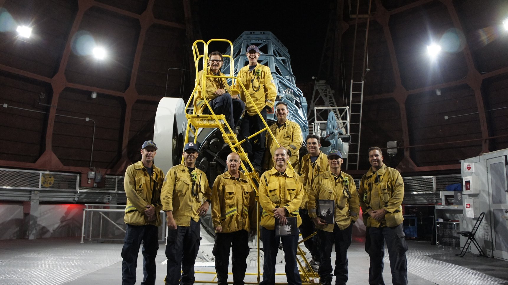
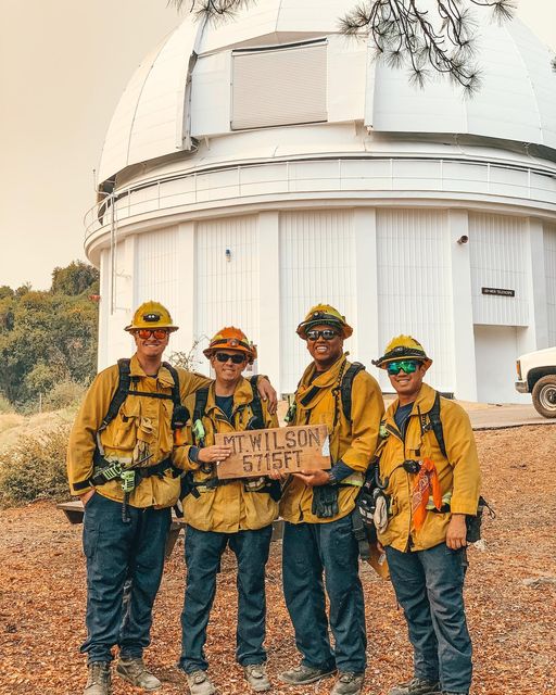
 Mount Wilson staff thanked firefighters from Ventura County Fire Department by showing them views of Jupiter, Saturn, Mars, and the Moon through the 60 inch telescope (posted by Mount Wilson Observatory pm Sept 27). Photo of firefighters who worked hard to protect Mount Wilson (by David Cendejas, posted on Facebook by Mount Wilson Observatory on Sept 29).
Update 2020 Oct 01
The last few days have remained fairly calm on the mountain. There are still many fires meandering around the canyon to the north of Mount Wilson which tend to flare up in the afternoon. The fire crews have removed miles of hose that was laid across the mountain, however, hoses remain in place at all Observatory fire hydrants.
Currently, access to the Angeles Forest is still closed from both La Canada and Palmdale. There are still many large engines, water tenders, and other fire fighting equipment, traveling along Red Box Road.
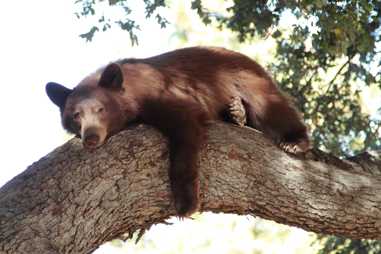
One of the noteworthy side effects of the fire is that both Larry and Craig have encountered bears taking refuge on the Observatory grounds.
Update 2020 Oct 02
The fire in the canyon north of Mount Wilson flared up again this afternoon with a large smoke plume visible in the HWREN cameras. The Angeles National Forest reported that they are doing a burn out operation in the Red Box area by Mount Wilson. They are "removing unburned fuels in an island deep within the valley. Firefighters are on scene monitoring the area. The operation is going as planned."
According to superintendent David Cendejas, the Division Chief has given clearance for maintenance staff and residents to return to the mountain. Caltrans will have a list of approved names that have been cleared to pass through the checkpoint at the bottom of Angeles Crest Highway SR-2 in La Canada.
Craig and Larry washed the ash and grit off of all CHARA telescope domes and bunkers today using the fire hoses. Over the weekend Diana and Larry will begin cleaning and sanitizing the buildings. Next week the interiors will be cleaned using a special vacuum system purchased after the Station Fire.
Update 2020 Oct 6
The large burnout in the canyon north of Mount Wilson, mentioned in the previous update, continued to burn throughout Friday night and during the day on Saturday (Oct 3). It didn't appear to make an aggressive run over the top of the slope, but a 180 degree shift in wind direction brought thick smoke over the Observatory several times. According to David Cendejas, this is a pocket of unburned fuels on an interior island within the containment lines. LACFD and USFS are monitoring the burn.
On Monday (Oct 5) Larry Webster reported that "Yesterday was the first day in several weeks that there wasn't a large fire raging in the north canyon. There are still several smoldering spots on the mountaintop, but firefighters have been working on extinguishing these on a daily basis. Overall, it's looking like an end to this fire monster may be in sight. The forecast for cooler temperatures and higher humidity is also welcome."
Several of the small smoldering spots are in Strayns Canyon near the Observatory wells. The fire agencies are aware these and keeping watch.
Cleanup work continues on the mountain. Over the past few days, the CHARA Control Room and Office building and the Cadman Cottage have been cleaned and sanitized. Both had been used by firefighters as they fought to protect the Observatory. Nils Turner turned back on many of the CHARA computers and Steve Golden cleaned ash from the Coude area at the E1 telescope. The day crew will continue cleaning the telescopes during the week.
Update 2020 Oct 16
The Bobcat fire is currently at 115,796 acres with 92% containment. The immediate threat to Mount Wilson seems to be over, although there are still smoldering hotspots in the area that occasionally flare up.
The majority of the Angeles National Forest has reopened, however, all hiking trails, Forest Service owned roads, and the land surrounding the Observatory will be closed until spring of 2022. The full listing of closures is available on the Forest Service website.
The CHARA staff continues to make progress toward reopening the array. All of the telescope domes have been cleaned. Judit and Laszlo Sturmann spent several days restoring system operations and checking alignments in the beam combining laboratory and out at the telescopes. The MIRC-X camera has been cooled down. Theo ten Brummelaar plans to check the functioning of the deformable mirrors in the adaptive optics systems at the telescopes next week. The CHARA staff expects to complete the final round of system checks next week which could open the door to possibly returning to observing during the last week in October.
The main hindrance to observing will continue to be the enormous amount of ash in the area surrounding the mountain. A small amount of wind can stir up the ash into the air. Ash can cause serious damage to the mirror coatings, so we have adopted more restrictive wind and relative humidity limits for when we can safely open the telescopes. These restrictions will stay in effect at least until the first significant rain occurs. On Friday night, Chris Farrington reported that there was a significant amount of ash in the air with wind gusts less than 10 km/h.
The devastation of the Bobcat fire remains mostly out of view during the drive up to Mount Wilson. This is mainly because the Mount Wilson Red Box Road represents part of the eastern boundary of the fire containment line. This is in stark contrast to the Station Fire in 2009 when we had to drive through miles of gray, scorched earth to reach the observatory. Currently, there are definitely lines of sight where one can view the devastation of the Bobcat Fire in the distance. Most striking along the drive are the occasional stretches where the road and trees are painted pink from fire retardant drops. Bear sightings continue to be a common occurrence on the mountain.
Update 2020 Oct 23
The CHARA staff has been working hard to bring the Array back online. All of the telescopes have been cleaned to remove ash from the domes, and all of the systems in the lab and at the telescopes have been brought back online. We are still working with limited staff onsite due to the ongoing pandemic and are very thankful to the dedication of those who have been working diligently to return the Array to regular operations.
We prioritized bringing the MIRC-X beam combiner back online because of the heavy demand on the observing schedule. On Wednesday night (Oct 21) we attempted our first trial run of reopening the Array on sky. After a short period of trouble shooting, all systems in the Array were working well, and we were able to collect six-telescope science data with MIRC-X. We will continue with a mix of engineering and science work on Thurs-Fri, and expect to resume the regular observing schedule roughly on October 27th. Over the next few weeks we will also bring the remaining combiners back online too.
With over 115k acres burned in the Angeles National Forest, we are in a difficult position when it comes to observing. Any significant wind from any direction stirs up ash into the air which can then end up on the telescope mirrors. While the humidity is low, we are able to clean the mirrors after observing using CO2. Above 50% humidity however, the ash can stick to the telescope mirrors and potentially damage the coatings. In order to protect the Array and still resume operations in a timely fashion, we are restricting observations to times when the RH is less than 50% (where we begin to think about closing around 40%, and actively shutting down around 45% while the RH is rising), and when the wind rises above the 10 km/hr level. We understand that this may cause significant downtime and interruptions in observations, and we deeply apologize for any loss of time. These restrictions will be in place until the first significant rainfall which should lock the ash away from being airborne.
Update 2020 Nov 24
The scheduled reopening was delayed because of strong winds that caused an Edison power outage at Mount Wilson on October 26th. The high winds stirred up a huge ash cloud and rekindled some active fires in the area. The Observatory was running off of generator power until the morning of October 27th. After the Edison power was restored, CHARA staff spent two days bringing back up all systems after the outage and re-cooling the MIRC-X camera which had warmed up during the outage.
The regular observing schedule finally resumed on the night of October 28th. The observing restrictions on relative humidity (< 50%) and winds (< 10 km/hr) limited the amount of time that we could safely open the telescopes, but it was great to continue collecting science observations again.
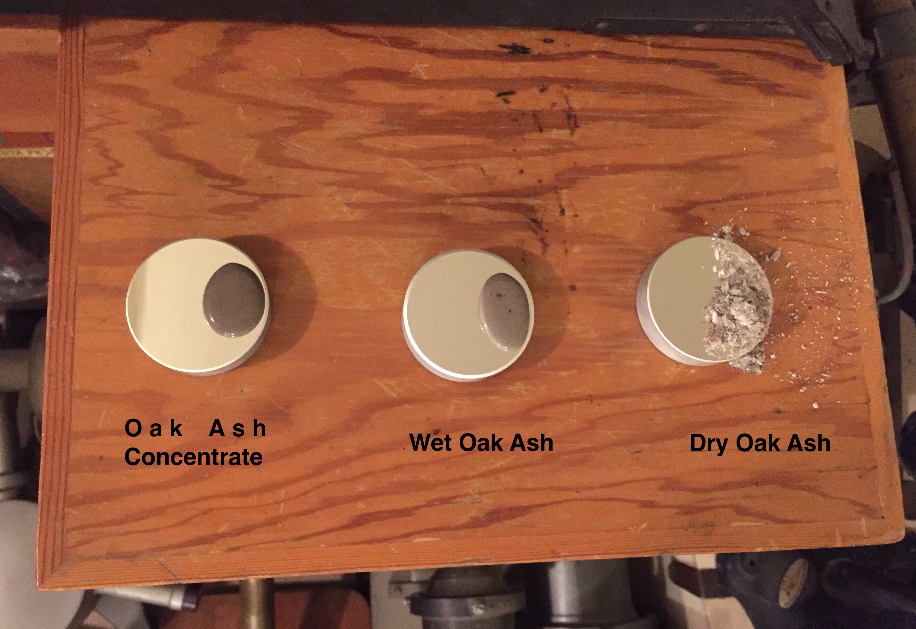
On October 26th 2020, Larry Webster conducted an experiment on the importance of removing ash from mirror surfaces. He reports:
Did a little experiment. I had 3 test flats with perfect coatings I had put on about 3 years ago. I gathered some fresh Oak ash from the grounds.On one mirror I sprinkled some dry ash. On another I made a thin water solution from the ash and placed it on the surface. On the third mirror, I had boiled down the ash solution into a concentrate as if I were making old fashioned "Lye Soap" and put that on the surface. Then I left them alone in a clean dry environment for 48 hours. (See images below.)After washing off the ash from all three, you can see the results. The dry ash mirror on the right was completely unaffected. The center mirror had its coating thinned by about half and stains were left behind on the margins. In other words, it was turned into a bad beam splitter. The coating of the left mirror with the ash concentrate was completely stripped!
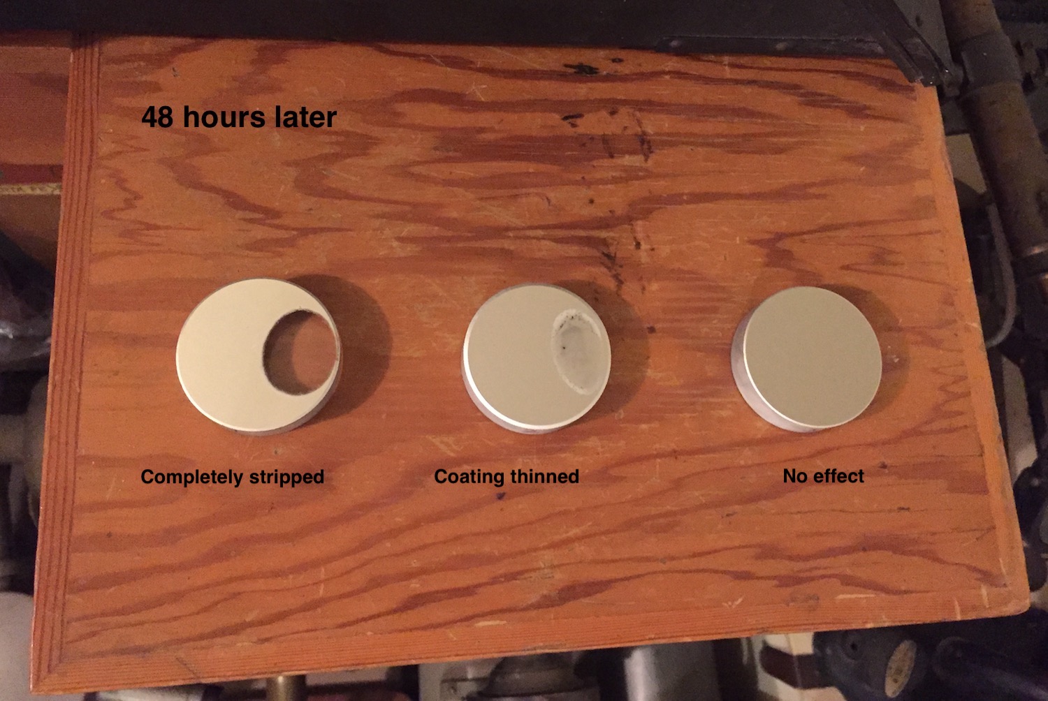
Mirrors before and after the ash experiment conducted by Larry Webster.
Mount Wilson experienced light snow and rain on Nov 7-9, 2020. The amount of precipitation was not enough to completely remove the ash threat. However, enough ash has been removed to lower the observing restrictions to relative humidity < 60-70% and wind gusts < 20 km/hr. Science observations continued on November 11, 2020.
Page maintained by Gail Schaefer. Based on information provided by the CHARA and Mount Wilson staff located on the observatory grounds, from the Incident Information System, and posted by the Angeles National Forest and the Mount Wilson Observatory. Information, links, and photos were also collected online by members of the CHARA staff. The High Performance Wireless Research and Education Network (HPWREN) cameras are operated through the University of California San Diego, led by the San Diego Supercomputer Center and the Scripps Institution of Oceanography's Institute of Geophysics and Planetary Physics.